During natural disasters, emergency centers get overwhelmed, and the first responders don't
know which areas need immediate attention and the number of people affected in a particular
site. So, when a disaster occurs, the drones retrofitted with our edge device can be deployed
in the affected area to monitor and gather useful information(in the form of images and real-
time stream).
The collected images and the responses are analyzed(using image processing and OpenCV)
to extract critical information, such as the number of victims, type of emergency, and location.
This information is then aggregated and visualized as a heatmap in the responder's
dashboard, prioritizing areas with the most need.
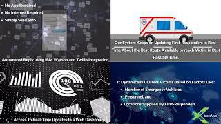
XtressVue then provides first responders with a map identifying areas with high emergency
levels based on the number of people involved and the urgency of the situation.
XtressVue analyzes drone and satellite imagery using semantic segmentation; this real-time
drone and satellite imagery analysis enables rescue workers to quickly reach victims by
generating routes avoiding damaged buildings and roads. Thus, accelerating the rescue
process and saving more lives.