
Altitude sensing reports a device’s elevation, expressed as height above mean sea level or above a local reference. LoRaWAN altitude devices derive this value in one of two common ways: from barometric pressure, where measured air pressure (and temperature) is converted into height, or from a GNSS/GPS module that reports altitude directly. The reading is encoded into a compact payload and uplinked over the long-range, low-power network at fixed intervals or on change.
Typical applications include drone and asset tracking, mountain and trail monitoring, flood and water-level context, building floor detection, and weather and environmental stations where elevation adds context to other measurements.
When comparing devices, look at:
- Measurement method (barometric vs GNSS) and stated vertical accuracy and resolution
- Battery life, reporting interval, and power draw
- Enclosure rating (IP) for outdoor or harsh deployments
- Supported regional frequency plans and LoRaWAN version
- Availability of a payload codec for your network server
Pair altitude with pressure, temperature, or GPS data for richer, calibrated results.
No devices match
Try broadening your search.
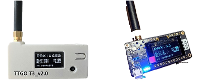
ESP32-Paxcounter
The ESP32-Paxcounter has sensors for battery, GPS, altitude, temperature, humidity, barometer, pm2.5, and …
 ✓ CERT
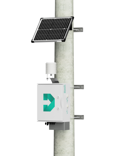
Urban Air Quality Monitoring Station
The Develiot Urban Air Quality Monitoring Station equipped with a wide range of sensors such as air quality …
Top vendors
Manufacturers with the most altitude devices in the catalog.
Related
Frequently asked questions
How do LoRaWAN altitude sensors measure altitude?
Most derive altitude from barometric pressure, converting the measured air pressure (and often temperature) into a height above sea level. Others read altitude directly from an onboard GNSS/GPS module. The resulting value is encoded in the LoRaWAN payload and uplinked at scheduled intervals.
How accurate are LoRaWAN altitude readings?
Accuracy depends on the method. Barometric altitude is sensitive to weather-driven pressure changes and usually needs calibration to a reference; GNSS altitude is independent of pressure but typically has a wider vertical error than horizontal. Check the datasheet for resolution and stated error.
What frequency plans do LoRaWAN altitude sensors support?
They operate on regional ISM plans such as EU868, US915, AS923, and AU915. Confirm the device matches your network’s plan and that a payload decoder is available for your platform.