Thanks for the example, I now understand it  .
.
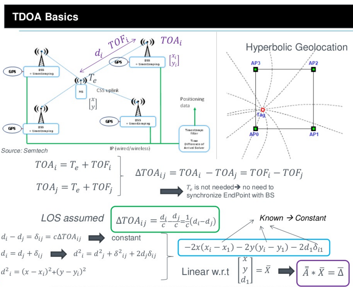
So:
- The node is sending a signal
- Gateways will pick up the signal and send it to the cloud with a timestamp of arrival.
- The cloud calculates the calculation with hyperbolic curves.
Thanks for the example, I now understand it .
So:
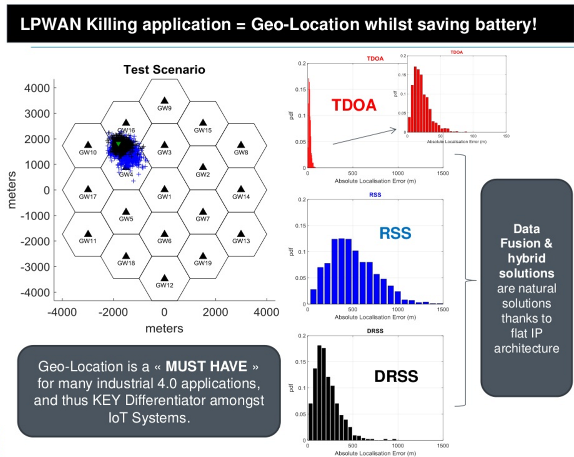
This slide from the presentation also presents the importance of gateway coverage when using this method of geo-location.
And it will be a killer-feature if we can use this!
Hi @FredH do you have the entire presentation to share?
Hi All,
I intend to create a (Apache Spark) cluster application based on streaming (big) data to calculate the position. I am searching for a Python library which I can use to do the TDOA calculations. Does anybody know a good library?
Kind Regards,
Ruud
I just ripped a few (interesting) slides from http://www.slideshare.net/titidelparis/io-t-sagemcom-m2minnovationworldgeotrackv08 that was shared earlier in this thread by @nestorayuso ! Earlier I urged Wienke to include a GPS in The Things Node on Kickstarter (and still think it would extend and upgrade many usecases for the node!) and then went after geo-localization / triangulation with/on the network. So happy it can be done, but think you at least need a GPS in all the gateways for exact synchronized timing, see this other slide from the presentation by SagemCOM:
As you can see in the Kickstarter, there will be GPS inside the gateways:

And yes, localisation would help a lot of killer apps come alive  Hope to see an open source implementation ending up in our example handlers coming up some day (any takers?).
http://pylayers.github.io/pylayers/notebook/UserManual.html
This is what you are looking for @Ruud ?
Thanks @FredH,
It looks great!
I will update this forum when my application is finished.
Btw: what class will the Kickstarter gateway support? It seems even the Kerlink (the carrier-grade gateway) only supports class A. I was surprised by this.
 geo-localization by triangulation as part of the network functionality of TTN is mentioned by @johan in the recent network architecture update, great this is confirmed! It also will become important to use open standards in the higher OSI levels, like the OGC framework for sensorwebs.
is it possible for a node to determine if geo location is possible on that specific location, ‘how many gateways do I see >3 = ok ?’
@Arjan I don’t fully agree about not using GPS in nodes: you could have the GPS turned off completely and let a another sensor (movement, change of angle, noise) be the trigger to turn the GPS on and send the location of the node. Using the bi-directional possibilities of the network to let energy-friendly sensors trigger other, more energy consuming sensors and switches+devices, is the way to go for many smart usecases and still have nodes that run for years on an single battery charge!
@FredH in the situation that geo localization by the network is not possible, because there are not enough gateways in range, a gps unit can be switched on.
but that would be a cold start and therefore A- timeconsuming to get a sattelite fix and B- using a lot of energy
I agree that depending on the purpose of the node, there could be also an GPS unit onboard.
Not using just the base LoRaWAN specification and packets. Multiple gateways might receive a node’s packets, but only a single gateway will reply (selected by the backend servers). I do not believe there is some kind of “gateway ping” packet defined, gateways will AFAIK never send packets on their own, only when told to do so by some backend server.
To let a node know about localization possibilities, the backend server should figure this out and use some application-specific packet to tell the node AFAICS.
another good article, including RSSI Heatmaps, RTT and fingerprinting…
I don’t know whether I have got this wrong but can you only get accurate positioning if the gateways hold accurate synchronisation from a time-server - usually a global satellite navigation system?
I asked this to Kerlink regarding triangulation and their response suggested it isn’t possible with their gateways at the moment.
For DTOA (Differential Time Of Arrival) each gateway receiving the packet must me in sync with the others, else it’s not possible to tell who got the packet when and what the difference was. The method of syncing is arbitrary, but any satellite navigation system (GPS refers to the US system only, Gallileo, Glonass are not the same as GPS) would be a good source, imho.
Hi all,
I want to try to calculate the location of as much as possible sensors in a area, (world?) 24 hours a day. I have a hadoop cluster with, Spark and Nifi which can do this. Who can give me more informattion how can recognize sensors and gateways on the Internet?
Greetings,
Ruud