imho the maximum distance with SF11/125kHz, 14 dBm ERP (SX1276) is about 1000km if there is a free line of sight.
Maybe your right, but given how bendy the Earth is, its not so straightforward to prove.
yes 1000 KM … from a weather balloon or similar are possible. The 136 km (132 km) are “earth to earth” without amplifier and without directional antenna.
And you’ve personally verified the location of both devices at this time?
It’s not impossible… something lucky like meteor ionization trail… but that’s pretty far beyond the horizon unless you have substantial elevation at both ends.
In terms of theoretical range, the path loss is easy to calculate, a bit more challenging is figuring out the potential interference. Since at the really long ranges you are talking about space, what is “behind” the transmitter and also seen by the receiver could be a factor.
If you could get the ‘weather balloon’ to around 60km altitude then its possible.
Balloons don’t tend to go that high.
But you could launch two, to 20 km each and ping between them.
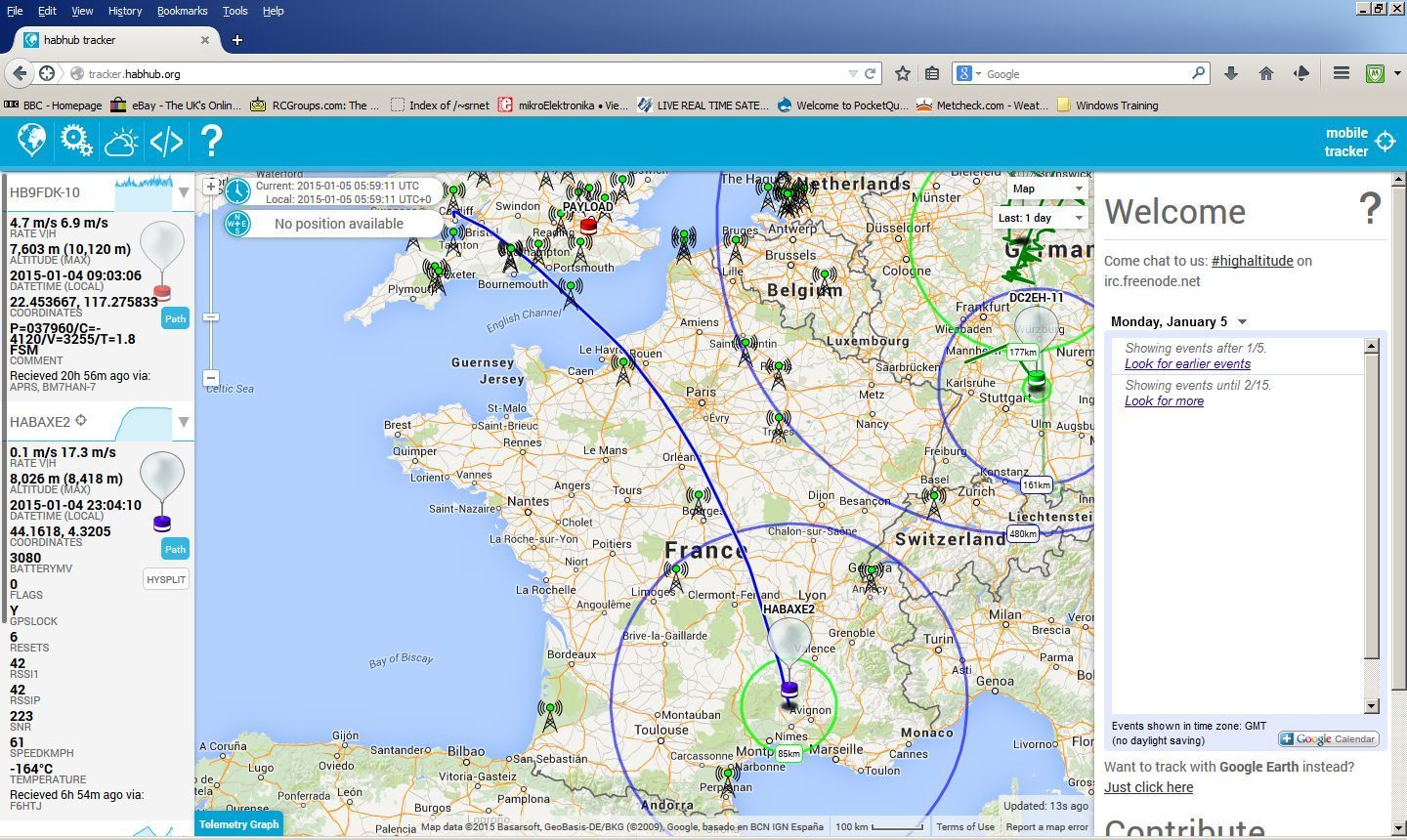
I think Dave Akerman has already done that - just not across a continent. His HAB tracker code base allows for balloons to relay messages so it’s just a matter of finding two launch sites far enough apart with good conditions at the same time whilst still vaguely daylight!
In my opinion, it’s a bit silly to focus so much on the records. Fun, but not so useful if you theoretically reach > 100 km, while I’m still seeing occassional loss over a distance of 1.5km in a city.
1 Like
Well I would admit to doing a few ‘silly’ things in my time.
Setting records does raise awareness of the technolgy that it might not otherwise get.
Before the days of TTN myself and the already mentioned Dave Ackerman were doing ‘silly’ things with LoRa, demonstrating very long distances at the end of 2014 and begining of 2015. Even Semtech were surprised at the long distance capabilities of LoRa being achieved with such simple equipment.
The very stark difference between what distance is achievable with good line of sight to a high altitude balloon for instance, approaching 1000km, demonstrates how much our standard communications can be improved by advantageous positioning of basic antennas.
2 Likes
 I well remember the internal reactions when highlighting one of the LoRa 2014 HAB flights that went over the Bristol channel, s.west England, over The Channel and a long way down towards Marseille (tracked by HAB enthusiasts for >1Kkm IIRC) - sadly the wind took it on a slow arc away from s.east France, to the south, as otherwise it would have taken it roughly overhead the LoRa Tech team (former Cycleo) down in the Grenoble region. I subsequently had the priviledge to set up and participate on a call with Mr.A & Nicolas for a discussion of the how and the art of the possible wrt LoRa (before LoraWAN, and even before the public roll out of LMIC IIRC) & Long Range HAB . Fun times!


(Blush) that was me. It went over the Britol channel because it was launched from Caerrphilly common, just North of Cardiff.
A simple foil party balloon, PICAXE microcontroller and LoRa device. I was the only one able to track with LoRa (from my shed in Cardiff) there were at the time only about two other HAB guys with LoRa receivers. It was tracked down to Marseilles via its FSK RTTY output.
I recall the surprise in the HAB community when I remarked that i was able to control what the foil party balloon was doing, send LoRa mode tests, turn off transmissions etc, whilst it was over 200km away.
Sorry Stuart - you are dead right! Was looking for my variant of that picture to add to post…I remember the PICAXE… even have one lost spares box that I picked up shortly after off the back of that story…
Now part of LoRa marketing folklore! 

The choice of PICAXE was as a result of my PICAXE in space exploits and experience. Whilst many were puzzled as to why a PICAXE was used for that HAB flight it was the obvious choice for me, there were no ‘Arduino’ libraries for LoRa at the time and neither was there a PICAXE one so I stuck with what I knew.
“Occasional loss” is the norm in radio communication, especially in shared spectrum.
There are some useful similarities between ultra long distances under line of sight conditions, and short ones under obstructed conditions and even those subject to interference (at least when it’s not same-slope LoRa interference)
Some of the achievements posted are likely more in the realm of “occasional success” than “occasional loss”
Indeed and when I pitch LoRa to potential audiences I always call out Long Range as a ‘proxy’ for deeper penetration into absorbant environments - loss through double/triple glazing? Loss through old stone walls in castles/stately homes/national monuments? Penetration through concrete walls of nuclear reactors & particle accelerators for monitoring (yes that is a use case!  ) Deliver sensor data through multiple floors of high rise housing or office blocks etc… All absorbant materials effectively do (simplistically) is pack an equivalent of a long free space loss into a shorter physical space!
3 Likes
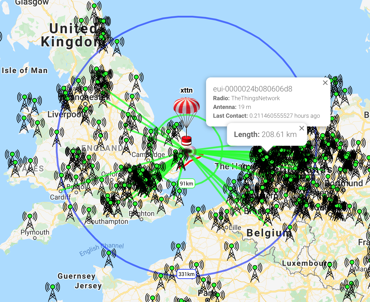
There’s a balloon flying right now over the north sea being tracked through TTN gateways:
https://tracker.habhub.org/#!mt=roadmap&mz=11&qm=1_day&f=xttn&q=xttn
Probably using my https://revspace.nl/TTNHABBridge “middleware” to relay data from TTN to the habhub webpage.
The blue circle is the “radio horizon”, i.e. the range from the balloon to the horizon as the balloon sees it.
1 Like
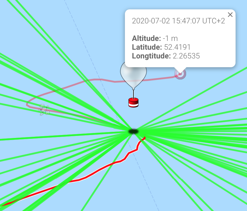
What’s that icon at -1 meter? Its coordinates don’t match the last position in the upper left.
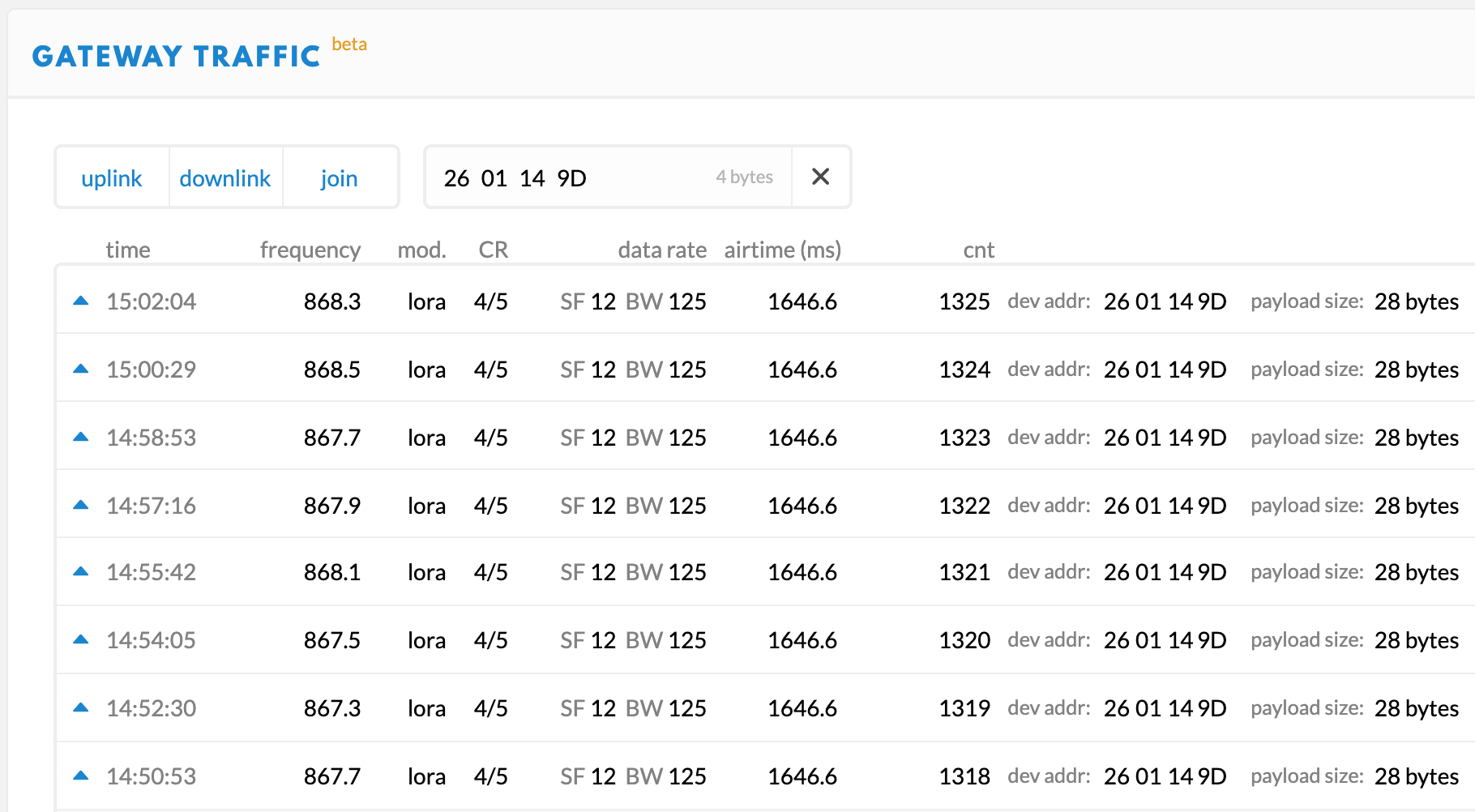
And it seems it’s DevAddr 2601149D:
I have been watching several hits on Local (Bourne End & Cookham) community GW in the N.West corner W/N.West of London at >200km and that is nothing to the ones going to Durham & TyneValley, Anglesey & West side of South Wales at >400km and can see several over in N.Ireland at >600km! (even a couple some km outside the nominal radio horizon!)
The bright red line (to the south) is the path over ground the balloon has moved already, and the other red line (to the north) goes to the ‘target’, i.e. the estimated landing location, based on a weather model. Some balloons carry photo and/or video cameras, for those balloons people in a “chase team” try to retrieve the balloon with the cameras + pictures. The target icon gives a rough indication of where they need to drive to.
1 Like
Oops, it just opened the parachute when I made a screen capture.