If you do that, do be careful to parse the output from the GPS properly, its not unusual to see the output of a GPS report negative altitude when you near sea level and the quality of the fix is on the poor side.
hello @darren-oc, could you explain the “position error” ? I 'm quite of new on this, and I’m developping a LoRaWAN device with gps using the <TinyGPS++.h> library, for now, I’m just sending lat, lgn, speed, altitude. ( altitude because i’m working in mines and I need to know this value).
The chip itself can report a % of error? Could you help me to understand? Or send to me where I could read about it?
As standard the TinyGPS++ library will give you HDOP, horizontal dilution of position, which is a measure of accuracy, under 1.0 is good. Dont see how you can translate that into an actual percentage position error, since you would need to know where you are to work out the percentage error.
You can add customisation to TinyGPS++ so you could extract the VDOP from the GPGSA sentence for instance.
mmmm you want to use a GPS in a mine ?
I would imagine there will be no signals after a very short distance underground, how far underground have you had a GPS working ?
Nice to know, I ll try to find how can I get this HDOP right now. Percentage was just a “guess” but I understood, near to 1 is good ! The mine that I’m talking about is an open pit mine.
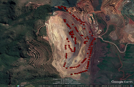
There is several different levels (as you can see in this image), in order to identify which level of the road my sensor is I ll use the altitude.
Ah, an opencast mine, we even have those in South Wales!
Whilst the opencast mine might be ‘open’ once you go down the hole the GPS can loose sight of satellites around the horizon, so fewer satellites in view, accuracy is reduced and height errors in particular can become significant.
One of those things you would have to test for your particular circumstance.
What are you going to be tracking the postion of ?
1 Like
I did some tests and we had quite of good results. The line in red represents a commercial GPS for vehicles and the “circular points” are the coordinates from my lora device.
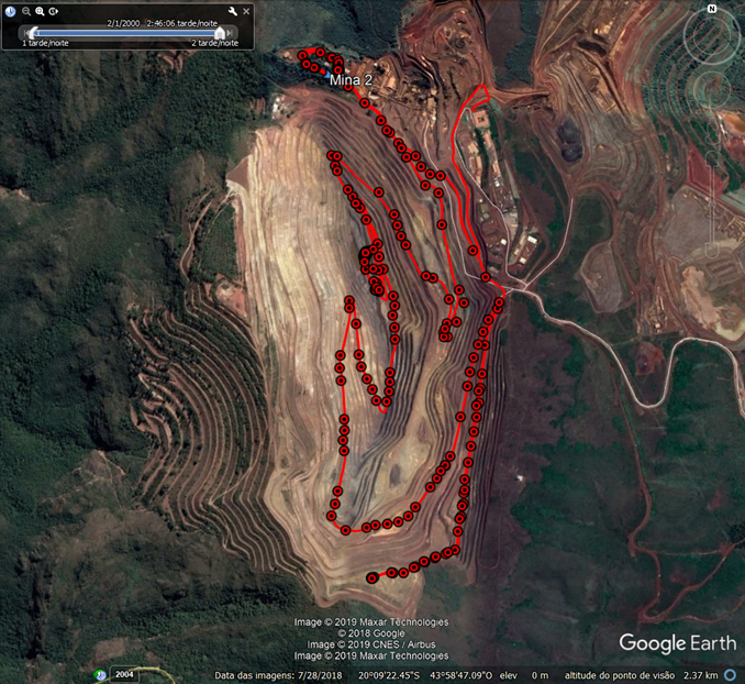
The climatic conditions were good in the day of the test Temperature min 24 ºC , max 32 ºC, the relative humidity was 22%-57%.
We would like to track some grader,hidraulic shovel,sandvik mobile screen, trucks. I think can be a nice project for lorawan, because is an open space. I need to pay attention in the GPS accuracy as you said, do you have any other tip? =)
The mine tip has around 400 m (depth)
I’m working in Brazil !
Tracking moving trucks might not be a good fit for TTN, remember the fair access limit of 30 seconds air time per day.
Yes, for this specific project I was thinking about a private gateway pointing my packet forward to a private chirpstack server. Unfortunately I think that use TTN will not be possible.